ISSN: 2278 – 1323 International Journal of Advanced Research in Computer Engineering & Technology (IJARCET) Volume 2, Issue 1, January 2013
Review of Real Time Two Phase Navigation
Tracking Approach for Assisting Visually
Sanjay M.Malode Dr. S.K.Shriwastava Department of Computer Technology, Director, SBITM, K.D.K. College of Engineering Betul, India Nagpur, India.
Abstract— restrictedness is observed for visually impaired people. India
This is perhaps the most humbling of all the disadvantages
being the country with world’s largest number of blind, there is
associated with the loss of sight. A wearable device that can
a tremendous need of systems that can assist such people in
reduce dependence in all manners of interaction with all local
navigation in unfamiliar environment. This paper presents a
environments is of the utmost importance to increase the
review on vision aided systems and presents the outline of the
quality of life for the blind or visually impaired individual.
proposed low cost design for a navigation system for the visually impaired people using Android devices.
Assistive technology enables people with disabilities to
accomplish daily living tasks and assists them in
Keywords- Android, visual impaired person, blind
communication, education, work and recreation activities.
navigation, Guide dogs, GPS, image processing.
Principally though, it can help them to achieve greater
independence and enhance the quality of life. Of the various assistive technologies available, a special focus was put on
those that help blind or visually impaired people with their
One of the most important of the complex sensory systems in
humans is the vision system. This visual system forms the
One of the other techniques still used to assist a blind person
basis for almost all navigational tasks performed by human
is by the use of “Guide Dogs”. Guide dogs can help a blind
body. Without this facility, visually impaired people suffer
owner navigate around obstacles and find things like chairs
inconveniences in their daily and social life. A total loss of
and restrooms, and locations by name. Guide dogs are
eyesight is one of the most serious misfortunes that can
specially trained to guide their blind masters around obstacles
happen to a person. According to a census by World Health
and to help them find destinations on command. They are
Organization currently there are about 180 million people
trained to guide their masters around pot holes, mail boxes,
worldwide that are visually disabled, of which 55 million are
utility poles, low hanging branches, and many other things
blind and this population is estimated to be 75 million by
that could cause injury to the blind person. A guide dog is a
2020. India alone homes more than 15 million blind people
dog individually trained to assist a person who is blind with
navigation. They are trained to recognize and navigate
The first essential aspect is to find an application for a
around common obstacles such as pot holes, utility poles,
pedestrian navigation system with social relevance. The
curb cuts, mail boxes, and low-hanging branches, among
second issue is to develop an overall outdoor navigation
other things. The most well known of these is the Seeing Eye,
concept, i.e., covering the whole spectrum of navigation from
in Morristown, New Jersey. Only dogs that graduate from the
positioning to guidance. Imagine walking into an unfamiliar
Seeing Eye are properly called "Seeing Eye Dogs," all other
airport, the places that a person has to look for are: the ticket
dog guides are called "guide dogs." In some countries the
counter, security check-in, boarding gate etc. These places
term "guide dog" is also used to refer to assistance animals of
are hard to find even when the person can see the signs and
all kinds, but in the U.S., the term "guide dog" refers
for a visually impaired, it is almost impossible without help
specifically to dogs who assist owners who are legally blind.
from external sources. Everyday situations like these, present
There are several disadvantages of using a guide dog for
instance Although the dogs can be trained to navigate various
Accessibility to the environment is important for all
obstacles, they are partially (red-green) color blind and are
individuals. Access includes not only physical mobility, such
not capable of interpreting the street signs, also Guide dogs
as making a trip to a store by the selected mode of
go through extensive training. It takes between 2 and 5 years
transportation but also being able to recognize key points or
for a guide dog to be ready to be matched with a disabled
decision points in the environment. For many blind people
person and the person should be compatible with the dog.
the loss of sight is paralleled with the loss of independence.
ISSN: 2278 – 1323 International Journal of Advanced Research in Computer Engineering & Technology (IJARCET) Volume 2, Issue 1, January 2013
Similarly, the use of SONAR systems though effective, is
Loomis [8] proposed a model to assist navigation for visually
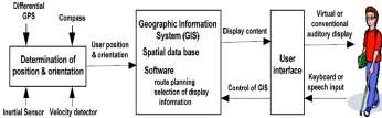
impaired people and proposed that any such system can be organized in three basic components:
Finding one's way through the environment depends on two
1) The position unit and orientation is responsible for
distinct 'processes: navigation through large scale space and
supplying the navigation system with the user’s spatial
the sensing of the immediate environment for impediments to
location, in the form of local and global coordinates. Due to
travel, such as obstacles and drop-offs. Navigation, in turn,
the strong dependence on the environment in which the
involves updating one's position and orientation during travel
system is used, this is the functional block that more
specifically characterizes the navigation systems;
Two commonly used techniques for many years to aid a
2) The geographic Information System (GIS) contains main
blind person is the use of a long cane and the guide dog. From
geo-referenced database system data. This functional block is
the early 1950's several efforts in the provision of travel aids
an essential component of the navigation systems. Its main
for visually impaired people have been made. They range
function is to store additional information about user’s
from the simple cane to advanced computer based aids. While
position, navigation maps, object positions and possible
the development of other assisting devices such as Braille
electronic reading machine to aid visually impaired people in
their everyday life has been very effective [2].
3) The user interface is the most critical component in the
navigation system for assisting the visually impaired because
In 1991, Golledge et al; were the earliest to propose the
it acts as a substitute for vision sensing (or attempts to). The
use of GIS, GPS, speech, and sonic sensor components for
user interface must be user-friendly in such a way that the
blind navigation in a progress notes on the status of GIS [3].
user does not encounter difficulties which would impede
MOBIC, is a GPS based travel aid for blind and elderly. It also
daily use. Typically interaction with the visually impaired is
uses a speech synthesizer to recite the predetermined travel
through audio interfaces, like Text-To-Speech (TTS) or
journey plans [4]. This test prototype is implemented on a
virtual audio (sonification) and tactile displays like Braille
handheld computer with preloaded digital maps and limited
wireless capabilities to get latest information from a remote
database. A similar system was implemented by Golledge et
Another pioneering work by Zelek et. al. involves stereo
camera and was designed to provide information about the environment through tactile feedback to the blind [6]. The system comprises of a laptop, a stereo head with two cameras and a virtual touch tactile system. The tactile system is made
up of piezoelectric buzzers attached to each finger on a glove
worn by the user. Here the cameras capture images, and the disparity is calculated from those images. The depth
Figure 2. Functional block diagram of the navigation system proposed by
information is conveyed to the user by stimulating the fingers.
In this work no image processing efforts are undertaken to highlight the object information in the output. More over the
Thus in general most of these systems available suffered
In particular for outdoor navigation the availability of
GPS-compatible cell phones and PDAs prompted appearance
of a number of software products, some of which have
Limitations in capability and usefulness
accessibility features making them potentially suitable for the
IR requires line-of-sight Active transmission requires
blind and visually impaired users. An example of such
software that provides verbal instructions is CoPilot Live [7].
Limited user studies to prove effectiveness, and thus
A number of electronic mobility aids using sonar have also
been developed to detect obstacles, but market acceptance is
rather low as useful information obtainable from them are not
Recent research efforts are being directed to produce new
significantly more than that from the long cane. The outputs
navigational system. Such a system should over the above
produced are also complex for user understanding.
mentioned drawbacks of the available visual aiding systems.
The infrared based Talking Signs [6] has been extensively tested and proved to be helpful, in particular for crossing intersections. This system uses directional infrared transmitters mounted in the environment, and a handheld receiver with a speaker.
ISSN: 2278 – 1323 International Journal of Advanced Research in Computer Engineering & Technology (IJARCET) Volume 2, Issue 1, January 2013
In this paper, a survey of different systems to facilitate movement for visually impaired persons is presented. Further an efficient and low cost two phase navigation system for visually impaired people using Android phones is proposed. Since the proposed model is a built in app for android OS there is no need to purchase separate expensive visual aiding instruments, thus making the proposed system a low cost one.
Figure 3. SVETA - A Stereo Vision based system
http://www.who.int//mipfiles/2400/AllenFoster.pdf [2] F. Wong, R. Nagarajan, S. Yaacob, A. Chekima and N. E.
Other terrestrial navigation support using augmented reality
Belkhamza. "Electronic travel aidsfor visually impaired - A guided
is developed for the sighted people. Metronaut, is a CMU’s
campus visitor assistant that uses a bar code reader to infer its
position information from a series of bar code labels
[3] R.G. Golledge, J. M. Loomis. R.L. Klatzky. A Flury and X. L.
placed at strategic locations of the campus [9]. Attempts
Yang."Designing a personalguidance system to aid navigation without sight: progress on the GIS component".InternationalJournal
are also made to use computer vision techniques for outdoor
of Geographical Information Systems. Taylor and Francis Ltd.
augmented reality applications. Behringer et al; have
developed a system based on the use of horizon silhouettes
[4] H. Petrie, V. Johnson, T. Strothotte. A. Raub S. Fritz, and R.
for precise orientation of camera to the user’s view [7-11].
Michel. "MOBIC: Designing a Travel Aid for Blind and Elderly
This approach is more applicable to natural terrain
MitigationLondon, 1996, 49(1): pp. 45-52.
Since GPS does not work inside a building, most systems rely
[5] R.G. Golledge, R.L. Klatzky, J. M. Loomis. J. Spiegle and J.
on relative positioning using sensors such as active badge,
Tietz, "A geographicalinformation system for a GPS based personal
digital tags, accelerometer, temperature, photodiodes and
guidance system'". International Journal ofGeographical
beacons [10][11]. The People Sensor, an electronic travel aid
Information Science. Taylor and Francis Ltd. London. 1998. 12(7): pp. 727-749.
for the visually impaired, uses pyroelectric and ultrasound
[6] J. Zelek, S. Bromley. D. Aamar and D. Thompson, "A haptic
sensor to locate and differentiate between animate and
glove as a tactile vision sensory substitution for way finding".
inanimate obstruction in the detection path [12].
Journal of Visual Impairment and Blindness, 2003. pp. 621-632. [7] S. Long, D. Aust. G. D. Abowd and C. Atkeson. "Cyberguide:
Prototyping Context-AwareMobile Applications". In CHI "96
Advancements in technology have led to the development
Conference in Engineering. Publisher, 1996,pp.293-294.
and integration of navigation systems and media into the
[8] Loomis, J.M., Golledge, R.G., Klatzky, R.L., Speigle, J.M.,
mobile hardware. This is useful for receiving and processing
Tietz, J., “Personal guidance system for the visually impaired”,
different satellite signals like GPS and are used for
Proceedings of the First Annual ACM/SIGGAPH Conference on Assistive Technologies, Marina Del Ray, CA, October
emergency calls. In many of these applications, real-time
31-November 1, 1994, pp. 85-91. New York: Association for
capability implicitly plays an important role. But, only little
effort has been put into using real-time capability of mobile
[9] Y. Kawai and F. Tomita, "A support system for visually
phones. Position-based navigation (called pilotage or
piloting) relies on external signals indicating the traveler’s
information using acoustic interface"'.IEEE 16th conference on
PatternRecognition, 2002, 3: 974 -- 977.
Since there has been a tremendous increase in android phones
[10] S. Ram and J. Sharf, "The People Sensor: A Mobility Aid for
in the market, the proposed navigation system is built for
the Visually Impaired", TheSecond International Symposium on
Android smartphones and tablets. The system employs the
Wearable computer. Pittsburgh. PA, 1998, pp. 166-167. [11] C. Randell and H. Mailer.''Context byanalyzingaccelerometer
use of GPS, where the GPS module sends the current location
Data". The Fourth International Symposium on Wearable computer.
to the device, which is reverse tracked to give the exact name
of the location and is then used to guide the visual impaired
[12] A. Smailagic and R. Martin. "Metronaut: A Wearable
person towards the destination by instructing him/her
Computer with Sensing and Global Communication Capabilities".
through the correct path. The proposed system is a two phase
The First International Symposium on Wearable computer.
system as it employs both current real time measurements
and also past history. For example a person uses the system to
move from A to B for the first time and on the next day he
wants to again go from A to B, then in this case the system takes into account the previous history to better assist the person on repeated paths, thereby felicitating fast and quick response time.
The next step in the evolution of vodkaGinSEnG Vodka – thE fiRSt SwEdiSh Vodka baSEd on a natuRal foRmulaGinseng Vodka is a high-quality vodka based on Swedish spring water and one of the world’s oldest natural formulas – Ginseng. Ginseng as an ingredient rounds off the characteristic edge of alcohol, normally present in traditional vodka, to create a smooth, pure and sophisticated vodka.
Cognitive Rehabilitation Factors to Consider in Choosing Appropriate External Memory Aids and Strategies KNOWLEDGE DA for People with Acquired Brain Injuries An external memory aid is anything that is outside of the individual that serves to aid memory. They are designed to store information externally to cue individuals to take action. Examples include reminder
 ISSN: 2278 – 1323
 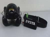 ISSN: 2278 – 1323